Trip #14 - North and South Dakota
- Emily Lubbers
- Jul 18, 2020
- 22 min read
Updated: Feb 8, 2021
Want to know what makes traveling difficult? COVID-19. I really shouldn't complain though. There are a lot worse things about COVID-19 than the travel restrictions. If anyone would have told me the hot mess 2020 would be, I probably wouldn't have believed them. I may have even laughed at them. But it has been a hot mess and all we can do is take it one day at a time. Needless to say, when our anniversary rolled around, Corey and I were anxious for a weekend away from the stresses of the real world.
Corey and I had barely made it home from Asia before Ohio issued a stay at home order back in March (more on Asia later, I promise), so we were a little wary of trying to plan another trip during COVID. We knew we couldn't go crazy, but traveling for our anniversary is something that is important to us. We wanted to make sure to celebrate our marriage in a way that fit our relationship. AKA trips not gifts. After a particularly crazy week we decided to go for it and planned a trip!
Due to our previous travels and my lack of remaining PTO, I would only be able to take 2-3 days off work for this trip. That meant we could go somewhere we had to fly to, but not so far that travel time would kill an entire day. We settled on checking out North and South Dakota. Due to the low population and density, we thought these would be good places to travel to celebrate our marriage but also stay safe and healthy. The itinerary included Wind Cave National Park, Badlands National Park, Black Hills National Forest, and Theodore Roosevelt National Park.
Originally we were only going to do South Dakota and save North Dakota for another trip. We could have easily spent more time checking out the Black Hills Region of South Dakota. But really, when were we ever going to go on a trip just to North Dakota? We decided to go big and try to knock it all out at once. I was a bit nervous about cramming in a different park every day but the trip turned out perfectly.
We planned the trip for the long weekend (Thursday-Monday) of our anniversary. Corey and I got up bright and early on Thursday morning to catch a 7am flight to Rapid City, SD. The flight went smoothly. Everyone wore masks on the flight and most people were wearing them around the airport as well. I never felt unsafe or exposed. We landed in Rapid City around 10am Mountain Time (after a short layover in Chicago). We picked up our rental car and we were off to Wind Cave!

Wind Cave is one of the oldest national Parks. Established in January of 1903, it was the eighth national park and the first national park to protect a cave. At 28,295 acres, the park is also the eighth smallest national park. The visitor center inside the park is located about an hour from Rapid City. Wind Cave is also free to visitors, they only charge for the guided cave tours.

We arrived at Wind Cave and immediately went to the visitor center to grab a park map and any important information they may have posted. The park did not disappoint! Before we even made it to the visitor center we pulled over twice! Once to check out some bison hanging near the side of the road and a second time to check out prairie dogs! I'm pretty sure prairie dogs are the squirrels of the big sky region! They were EVERYWHERE!

We made it to the visitor center and planned our route for the day. One thing to note is the cave was closed at the time of our visit due to COVID. While at first I was extremely disappointed about this, the Wind Cave hiking trails are considered to be some of the most underrated hiking trails. After spending the day hiking the trails of Wind Cave, I would have to agree. They were pretty amazing.
There are 8 main trails ranging from 2.8 to 17.2 miles in the park, most of which are out and back trails. There is another series of 3-4 trails that are each less than a mile, some of which include interpretive signs along the way to help you learn about the park's ecology. Given that we had been up since 4am, and it was only the first day, we decided to keep it easy.
Once our plan for the day was set, we headed into the town of Hot Springs (about 15 - 20 minutes south of Wind Cave) to grab lunch. We settled on the outdoor diner, Dew Drop Inn Cafe. It was very cute and had killer milkshakes. Once we were all fueled up, we headed back to the park to start the hiking!

The first hike we did was Cold Brook Canyon Trail. This trail is a 1.4 mile out and back (2.8 total miles) trail. It is considered 'moderate' per the park's standards, but I would have considered it to be 'easy'. Other than the first (and last) 1/4 mile, it is was pretty much completely flat. The trail descends into Cold Brook Canyon and passes through a prairie dog village before it terminates at the park's boundary fence. The prairie dog village was fun. They are noisy little suckers! This trail is also very cool because of the changing landscapes. Most of the trail is through a field, but there are also cliffs, trees, wildlife, and even a wetland at the termination. It was such a great trail to start our vacation with.
For the most part the trail was super easy to follow. The grass was pretty high in areas but there were posts that helped you keep your bearings. We did end up off the trail at one point but were able to easily find the next post and get back on track.
Biggest lesson we learned Day #1: Be sure to check for ticks when you are all done! Corey and I took a break part way up the hill at the end of the trail and he picked four, FOUR!, ticks off himself. I then found one on me when we got back to the car. *shudders thinking about it still*
Here are some photos from Cold Brook Canyon. You can click to enlarge!


Both of us were running low on energy due to our early start that day. We decided to take a small break at the picnic area. While relaxing, we both ended up falling asleep. While this meant we were going to have to cut out a hike or two, there is nothing like taking a nap with slight breeze and nature sounds all around you!
Once we woke up, we decided to drive through the park to the northwestern boundary to do one of the short trails before heading back to the city. Rankin Ridge makes up the southern border of the Black Hills (and northern border of Wind Cave). It also has the highest point of Wind Cave National Park at 5,013 feet. An old fire tower sits on the highest point. Rankin Ridge Trail is a trail that passes the fire tower and then loops around via a gravel path back to the parking lot. The trail only has a total climb of 250 feet and is roughly 1 mile.

This trail may be short and doesn't have a huge climb but man does it have some awesome views! We were super bummed we couldn't climb the actual fire tower but the view on top of Rankin Ridge is not to be missed!


Once we made it back to our car, we decided it was time to head back to Rapid City. At this point we were at the northern edge of the park and decided to take the scenic route through the Black Hills to get home. Not long into our drive we realized we were pretty close to Mount Rushmore so we decided to stop by and check it out. While I personally think Mount Rushmore is a little disappointing (it is so small!), the one bonus was the monument was free to visit when we stopped by. That means our entire day's worth of entertainment was free!

After Mount Rushmore we took the scenic roads through the cutesy town of Keystone and Custer State Park on our way back to Rapid City. In Custer State Park we stopped at Legion Lake and did a short trail around the lake before hopping back on the road. Once we made it back to the city, around 7 or 8pm, we stopped by a local grocery store and stocked up on supplies for the rest of the trip. We checked in to AirBnB, unpacked, made dinner and then called it a night.

Friday we hit all things Badlands National Park! After making breakfast and packing up a cooler / backpack we hit the road. Badlands National Park is approximately 1 hour and 15 minutes (via Highway 44) from Rapid City. You can get there via I-90 a bit faster but that puts you into the park on the opposite side as the visitor center.
Badlands National Park has two units. The North Unit and the Stronghold Unit. Fun fact: The Stronghold Unit is within the Pine Ridge Indian Reservation. On our way to the visitor center at Stronghold Unit, we were stopped and informed we could not go further because the Indian Reservation was closed to all non-residents due to COVID. We had to backtrack a bit to get to a road that would take us directly to the North Unit without going through the reservation.

Once we reached the park we stopped at the visitor center. After a brief chat with the sweetest park ranger about which trails he recommended, we made a detour to grab some sunscreen, and then decided to get started!
Badlands National Park was established November 10, 1978 and holds 244,000 acres of semi-arid land and a 60-mile rock wall known as the Badlands Wall. 900,000 people visit the park each year, with the peak season being summer. While summer is the most popular month to visit, it isn't unusual for the temperature to exceed 110 degrees! We were lucky and during our visit the temperature peaked right around 97 degrees.
There are 8 trails within the park. All but three of the trails are less than a mile. That makes it easy to hit most of the trails in one day. There are two longer trails, one 4 miler and one 10 miler. Given the temps of the day, we decided to knock out several of the shorter ones. Per the Ranger's recommendation, we started with Cliff Shelf Nature Trail. This 1/2 mile trail is a boardwalk loop that provides some great views of the Great Plains. There is a small juniper forest and many locations where the trail leaves the boardwalk where you can explore the surroundings.


The second trail we did was more of an overlook than a trail. Window Trail is a short path to an overlook through an eroded portion of the Badlands Wall that gives you a peak out over the badlands. The view was pretty cool, but the trail itself wasn't more than a short walk from the parking lot.

Off the same parking lot is a trail called Notch Trail. The Ranger told us this was a fan favorite and the trail did not disappoint. One of the longer trails we did that day, Notch Trail is a 1.5 mile out and back trail (3/4 mile each way) that takes you through a canyon, up a wood rope ladder, and terminates at an overlook of the Great Plains. A portion of the trail is along the edge of a cliff, so it is a good thing neither Corey or I are scared of heights.

The trail started as a dirt path from the parking lot and before too long hit a steep wooden ladder. Climbing up the ladder really wasn't too bad. Once at the top of the ladder you continue around the cliff edge and then further into the rock formation. This portion of the trail wasn't the easiest to follow. At first it was clear where the path was, but the further we went the more it became unclear. There are poles mounted that help guide your way, but at times it still wasn't easy to tell which path of travel was the intended route. The end of the trail was obvious as it stops at the edge of a cliff overlooking the Great Plains and the Cliff Shelf Nature Trail below. This was definitely one of my top hikes of the day.


The fourth hike we did, Door Trail, was in the same parking lot. This trail was the Ranger's favorite, and I can see why. This trail is marked as 3/4 miles (one way) but it really could be as long as you wanted to make it. The trail starts with a boardwalk leading you through an opening in the Badlands Wall into the badlands beyond. A set of stairs takes you down onto the rugged earth. There is a marked trail that leads you 1/2 mile further out into the badlands. This trail is very loosely marked and from what the Ranger told us, is meant to allow people to explore the badlands as they see fit.

From Door Trail we decided to head to some of the overlooks and stop for a picnic lunch. The main road through the park is the Badlands Loop Road. There are at least 10 different overlooks on this road. We started near the visitor's center and continued along the road checking out the different overlooks that caught our eye. There were two shorter trails we had planned on doing, but both were closed due to construction when we got there.

About 2/3 the way along the Badlands Loop Road we turned off at a picnic spot and ate lunch under a small shaded structure. Instead of heading up to I-90 to exit the park, we decided to take a the dirt Sage Creek Rim Road through the Badlands Wilderness Area. In terms of a dirt road this one was very well maintained. Unfortunately, we didn't see much wildlife other than bison. The dirt road took us all the way out of the park and eventually turned into a paved road that led us back to Highway 44 and back to Rapid City. Check out some more photos of the park in this gallery:


Once back at our AirBnB, we showered, made a nice steak and mac-and-cheese dinner and headed out to check out the local breweries. Similar to Asheville, we had an Uber drop us off at one brewery and we were able to walk to a couple more before heading home for the night. We started at Hay Camp Brewing Company, followed by Firehouse Brewing Company, and ended at Dakota Point Brewing. All of the breweries were good, but in my opinion, Dakota Point Brewing had the best selection and I enjoyed almost every beer we sampled.

Saturday we saw as much as we could of the Black Hills! Black Hills National Forest is a VERY large region. And, while there is a ton to do, our research showed that the majority of what we wanted to see was in the Custer / Keystone / Hill City region. I spent a lot of time googling 'Best Hikes in the Black Hills' and realized a couple things quickly.
1. Almost every 'best hike' started in Custer State Park.
2. Everybody recommend hiking Black Elk Peak.
Since there is a $20 admission fee to get in, we were trying not to go through Custer State Park. We also didn't want to spend the entire day doing just one hike, which ruled Black Elk Peak out. The shortest option for this peak (there are several ways to get to the top) is still over 7 miles. Instead we decided to start with Horsethief Lake Trail, another trail that popped up on a couple of the lists.
Horsethief Lake Trail (also known as trail #14) starts near Horsethief Lake, which is not part of Custer State Park. It is part of the Black Elk Wilderness region. This trail is an out and back trail that dead ends into Gizzly Bear Trail (trail #7) right in the middle of Black Elk Wilderness. You must register (which is free) in order to enter Black Elk Wilderness. There is a registration post at the trailhead. The trail is 2.7 miles point to point (more on this later).

Corey and I immediately fell in love with this hike. It started along a stream with bright green all around us. The forest was dense and broken up only by the occasional rocky boulder, some of which were covered in moss. The trail starts off relatively flat but about 1/2 mile in starts a moderate incline that never really lets up. Around 1.5 or so miles the trail starts to head down into what I can only dub a 'tree graveyard'. There were burnt trees everywhere. It was very cool, though a little unnerving to hike through.

It was about this point that Corey and I realized that we may have underestimated the length of this trail. All of the other trails on the website we were looking at gave the total length of the trail (out + back). It was clear that for this trail it had not. Unfortunately, Corey and I were only planning on doing the 2.7 miles, not 5.4 miles. While normally it wouldn't be a big deal, we hadn't packed enough water. By this point, we were almost out of water, \dying of heat, trying not to drink the little water we had left, and we hadn't even made it half way yet. We made the decision to turn around and head back to our car. We estimate that we made it about 2 miles out of the 2.7 miles.

One thing to note about this trail was after we got past the first 1/2 mile, we only passed 3 other groups for the rest of the hike. This was a gorgeous secluded hike for anyone who wants to enjoy the wilderness without running into people.

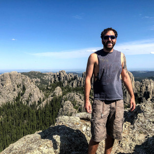
After finishing the hike we relaxed at the lake for a bit. We then decided to bite the bullet and head into Custer State Park. It was time to hike Little Devil's Tower Trail! While this peak is 200 feet lower than Black Elk Peak, the top of the peak comes with spectacular views of both Black Elk Peak and Cathedral Spires, as well as the surrounding Black Hills. At 3.6 total miles, this out-and-back trail is much shorter than Black Elk Peak and it definitely did not disappoint. The coolest part? The trail ends with a Class 3 scramble to the top of a large rock boulder that makes up the summit.

Given that this trail is a summit hike, it makes sense that it is mostly an incline to the summit. While definitely more populated than the first trail we did that day, this trail was stunning.
I was honestly a little nervous about the scramble at the end of the trail. The going up part never scares me, it is coming back down part I struggle with. While we were climbing the scramble there was a group coming down and one of the women was scared of heights AND in sandals. No thank you.


For those of you who don't know, a Class 3 scramble is part of the Yosemite Decimal Classification System. There are 5 classes. Class 1 is a moderate to steep hike that does not require any use of hands. Class 2 is a basic scramble. Rock scrambling is basically the term used for when you aren't walking, but you also aren't rock climbing. Basically, if you have to use your hands to climb it is a scramble. Class 3 is a scramble that involves exposure (has some level of a drop off / cliff). Class 4 is an in-between class. It is more challenging than a scramble but doesn't necessarily require rope support. Class 5 is straight rock climbing.
Check out the photo below.You can see the rock bald in it that makes up the scramble.

Once we reached the summit we decided to take a break to eat our lunch. After the first 5 or so minutes we were the only ones on top. Thanks to my awesome hiking boots (I recommend them to just about anyone who is willing to listen) heading down the bald was not nearly as bad as I envisioned it being. I didn't slip or fall once (which is an impressive feat for me).
Check out the video below for a panorama view from the summit. I apologize for the shaky/quick view. It was very windy and I was afraid of falling!
Once at the base of the trailhead it was time to hit the road and head to Montana, where we would be staying for the next two nights. While we were planning on checking out North Dakota the next day, the best accommodation I could find for us was over the border into Montana in a tiny town called Wibaux.
Here are some more photos of Little Devil's Tower Trail:


Traffic was pretty heavy getting out of the park. We stopped in Spearfish to have dinner at a local pub. The drive from the Black Hills to Wibaux (pronounced wee-bow) was about 4 hours and 15 minutes per google maps. Once we made it north of Spearfish, traffic cleared up and we were on 'back roads' the rest of the trip. It was easy to cruise at 85 (speed limit 80 - for all of you concerned about that) and we passed maybe 15 cars the entire rest of the drive.
To be honest, I was dreading the drive. I was tired and just wanted to make it to the next AirBnB. I very quickly found out there was nothing to dread. The drive was gorgeous. We went through a tiny sliver of Wyoming before hitting Montana. While the drive was flat, it was stunningly green with foothills in the distance. Corey and I spent the drive talking about our future dream of one day owning a house in Montana, and also guessing how many residents resided in each tiny town we passed. I'll give you a hint. It was almost always under 500, and often under 100.
Wibaux, Montana is an adorable little town. We stayed at the Palace Hotel, which is located in the same building as the Palace Cafe. We had a sweet little studio room with a gorgeous authentic tin ceiling. The accommodations came with vouchers for breakfast at the cafe! Corey and I settled in and drank a couple of the local beers we picked up when we were grocery shopping and called it a night.
Our last full day was spent checking out Theodore Roosevelt National Park. On Sunday morning Corey and I had breakfast at the Palace Cafe. It was delicious! We then hit the road to make the trek to the park.
Theodore Roosevelt National Park was created in November, 1978. It is home to 70,447 acres and sees 580,000 visitors, on average, per year. Theodore Roosevelt once wrote, "I would not have been president if it had not been for my experiences in North Dakota." Theodore Roosevelt first arrived in the area in 1883 and returned again, searching for solitude, in 1884 after his mother and wife died just hours apart. It is said that his time here influenced him for life and led him to conserve 230 million acres of land while president.

Theodore Roosevelt National Park has three units: The North Unit, The South Unit, and the Elkhorn Ranch Unit. Unfortunately the North Unit is about an hour from the South Unit (with Elkhorn Ranch in the middle). We decided it would be best to spend our time checking out as much as we absolutely could of one unit rather than trying to fit in two, or all three. We decided on the South Unit. The South Unit was about 30 minutes from our AirBnB in Wibaux.

Unlike some of the other parks, where you can drive around in the park for a bit before you hit the visitor center, at TR the Visitor Center is the first thing you come to. We hopped out, paid the entrance fee ($30), grabbed a map and planned our route.
One of the cool things about the South Unit is there is the Scenic Loop Drive that is a big circle that covers most of the unit. Unfortunately due to erosion, a chunk of the road was washed out and it was impossible to make a full circle. Not deterred, we decided to head out and do the hikes we passed and then once we hit the road block we would turn around and go out the way we came in.
I should insert here that I am SO glad that we decided to do this park and check out North Dakota as part of the trip. I would say this was definitely my favorite National Park of the three we checked out. I am assuming it was due to COVID, but the park was basically empty. I really don't think it is an exaggeration to say that we saw less than 50 cars inside the park the entire day.
There is a trail that is part of the South Unit that is accessible from a separate entrance into the park. This is supposed to be one of the coolest hikes of the South Unit so we decided to start there. The Painted Canyon Nature Trail (not to be confused with Painted Canyon Trail, which has a trailhead in the same parking lot) starts at the Painted Canyon Visitor Center (There is nothing else to do at this Visitor Center other than those two trails) The Nature Trail is 1 mile long and is a loop that takes you from the rim down into the canyon. This trail is considered moderate because what goes down must come up!


We hopped back in the car and headed back to the main part of the South Unit. Once we got back into the park it started to rain. We could tell it wasn't raining in other portions of the park so we decided to drive a bit and figured we would check out the trails we missed on the way out. Again, we did mostly short trails so we could see as much of the park as possible in the time we had. Here is a short summary of the trails we did:
Wind Canyon Trail: 1/2 mile 'easy' trail that gives you a beautiful overlook of the Little Missouri River. Highly recommend this trail.


Boicourt Overlook Trail: 1/4 mile 'easy' trail that was easily one of the most beautiful overlooks. We also saw ZERO other people on this trail so we were able to sit at the end and enjoy the view in private.

Buck Hill: 1/4 mile 'easy' trail that climbs to the highest point in the park. This trail is considered easy because it is short, but man is it steep! Once on top there is a trail that takes you further, if you desire. We walked it for a bit, but not all the way.

Coal Vein Trail: There are two loops (outer and inner) so the length of this trail depends on how you hike it. Somewhere between .5 and 1.5 miles. This trail came heavily recommended, but honestly, I didn't love it. I was also dying of heat by the time we were doing this one so that may have been a factor. The trail may not have wowed me, but the history is still cool. There is a 12' coal vein deep underground that caught fire in 1951 and burned for 26 years. When the coal burned out it caused collapses on the surface when the formations were no longer supported.
Skyline Vista: This is more of an overlook than it is a trail. You can see part of the badlands as well as the highway. While the view here is still beautiful, it was not nearly as cool as many of the others in the park, making it somewhat anticlimactic.
At this point we were hot and tired. We headed into the city of Medora (population 128) to get some ice cream and take a break. Who doesn't want ice cream for lunch when it is scorching hot outside?! After our short break we decided to head to the petrified forest. Fun fact: Theodore Roosevelt is home to the third largest petrified forest in the United States.
Similar to Painted Canyon, the Petrified Forest Loop Trail is accessible from its own park access point that is 3-4 miles down dirt roads. When we arrived at the gravel lot at the trailhead there was only one other car there. There are two sections to the forest, north and south. There is a full loop that is just over 14 miles that can be done that covers both sections. Due to the time of day, we decided to check out the north section of the forest only.
Within the first 1/2 mile of the trail we ran into a group coming out. They stopped us to let us know their phones had alerted them that storms were coming. You could see the storms in the distance, but they didn't look too bad so Corey and I decided to keep going. Getting to the north section and back would be a little over 3 miles.

This trail was gorgeous. It started out walking through a huge field full of wild flowers. Then you walk down a dirt cliff into the petrified forest. We spent a good time hiking around and checking out the forest. I find petrified forests absolutely fascinating. How does a tree turn into a stone?!

By this point we could see the storm over what looked to be where our car was parked. The storm didn't appear to be coming in our direction so we continued to check out the forest and wander around. However, at some point the storm shifted and started heading more towards us than it was previously. My biggest concern was making it to the top of the dirt cliff before the rain hit because I knew it would be almost impossible to climb wet.
Thankfully we made it to the top of the cliff without running into any rain. Once back into the field we were able to watch the storm approach. The clouds with thunder/lightening in the distance were really pretty in contrast with the field around us. We kept moving at a fast pace, attempting to make it back to our car before we hit rain. We almost made it! About a 1/4 mile from our car I got pelted with something in the face. It took me a second to realize it was hail!
Site note: When we were picking up our rental car at the airport, the woman from Enterprise explained to us that hail damage is not covered by any of the insurance coverage and that no matter what, if it hails your car is considered to have hail damage. A little surprised by this, I asked the woman if that is something that happens often in this area. She explained to me that SD/ND are known for having crazy hail storms with hail as large as cantaloupes! Thankfully our car already had hail damage when we picked it up, so we would not be responsible for any additional hail damage.
Normally hail wouldn't be much of a concern, but knowing that hail could get as big as cantaloupes was a bit alarming. Neither of us were interested in finding out just how much damage could be done by getting hit with hail that large. So we took off at a sprint (backpack and hiking gear and all). By the time we made it back to the car the hail was golf ball size and man did it hurt! Corey got pelted behind his ear and me in the face before we were able to safely make it into the car.
Once back in the car we caught our breathes and laughed while the hail pelted our car. It is easy to see how hail this large could damage a vehicle! It was hands down the largest hail I had ever seen! Thankfully we were safely in our car before the largest hail started to fall.

Done hiking for the day, I put the AirBnB into the GPS and started the trek back to Wibaux. Unfortunately, rather than taking us back the direction we came, the GPS attempted to take us on grass (yes, not even gravel, GRASS) roads. We also got stopped by a young prancing cow in the middle of the road. We realized we were better off turning around and just going back the way we came, whether it was the most direct route back to Wibaux or not. We definitely didn't want to get our car stuck on the back roads of North Dakota!
Here are a couple more photos from Theodore Roosevelt:


Fun fact: Wibaux, Montana - population 600 - has a brewery! Beaver Creek Brewery! Open Thursday - Sunday from 4pm - 8pm. After quick showers we decided to go check it out before it closed. They had 9 beers on tap. We were able to get a flight of all of them. Honestly, their beers were awesome! Definitely my favorite brewery of the entire trip!
After the brewery closed we wandered around town for a bit before heading back to our room to make dinner and relax. We still had some beer left from the grocery store so we drank that after dinner and relaxed before calling it a relatively early night.
When I originally booked the flights, our return flight left at 1:30pm. At some point it got moved up to 11am. This meant that we had to be on the road by 6am Monday morning in order to make it to the airport by 10am. Similar to our drive to Wibaux, we were able to cruise at a very comfortable speed while taking in all we could see of Montana on our way back to Rapid City.
We arrived at the airport right around 10am. Now for those of you who love to get to the airport 2+ hours before your flight, have no fear. The Rapid City airport has 7 gates. The process of returning our car, checking-in, going through security, and finding our gate took approximately 15 minutes. We were at our gate well before our flight even started boarding. After a short layover at O'Hare, we landed in Cincinnati around 7pm. Home sweet home!
Since this was our most recent trip, we do not currently have anything else planned. I am antsy to see what else we can squeeze in before the end of the year. I'll keep you guys posted on what we come up with!


Comments