Trip #8 - Iceland Days 4-7
- Emily Lubbers
- Aug 6, 2020
- 15 min read
Want to know how today feels? Like we are on day 5,999,999 of COVID life. It has been the most surreal passage of time over the last several months. Time feels like it is dragging by, but at the same time, I blink and it is August. Asia feels like it was both yesterday and years ago.
In the past, so much of my life has been focused on getting from trip to trip. From adventure to adventure. While I have no planned trips in the immediate future (though we are working on something fun - hopefully), it does help to relive the trips we have taken in the past. This blog has been a huge saving grace in that sense. It has been so fun to go back and look at photos we took. In some cases I am editing photos from the trip for the first time! Now, on to the second installment of Iceland, Days 4-7.
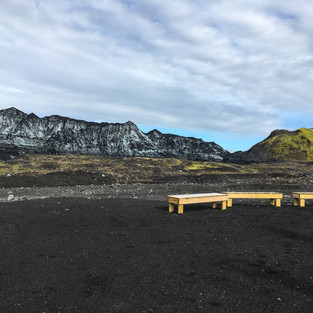
Day #4 was probably my favorite day of the entire Iceland trip. It was a good one, but it was also a LONG one. We had planned on checking out the black sand beach, Reynisfajara, and its cool rock formations on Day #3 but decided not to because of the rain. I wasn't willing to cross it off the list completely. We had an early excursion planned so that meant we had to get up even earlier to check out the beach before the excursion in order to stay on track the rest of the day.

This black sand beach is set apart from many of the others in Iceland because of the basalt column formations, Reynisdrangar. These rock formations can also be spotted in a couple scenes from Game of Thrones that take place north of The Wall.

From Reynisfjara we headed into the town of Vik to the meeting point for our volcano ice cave tour! Yup, you read that right. About an hour drive from the town of Vik is the Myrdalsjökull glacier. Hidden underneath it is the Katla Volcano. Katla is one of Iceland's most active and dangerous volcanoes with eruptions every 50-100 years. Unlike other volcanoes, Katla's eruptions wreak havoc in the form of major flooding due to the magma melting portions of the glacier above it.
After doing some research (because there are TONS of companies that offer tours) we settled on booking a tour through Arctic Adventures. The tour started in Vik where we met two large van / jeep vehicles. These vans drove a group of about 20 to the base of the glacier. From that point we geared up in special shoe covers and helmets.


There is no permanent cave the tour does. The glacier is constantly moving and changing. Therefore, the different caves are constantly changing, evolving, melting, and forming. The tour guides spend their free time exploring the glacier in order to locate different caves. This allows them time to prepare new caves with the proper ropes / safety guides so when one cave becomes unusable, a new cave is ready.

The scenery at the base of the cave was unreal. The wall that makes up the base is actually 'The Wall' from GoT. However, it is clear there is some heavy CGI that takes place because I personally did not see the resemblance. Once everyone was geared up we headed into the cave. While I would have preferred to spend longer, we only spent about an hour inside the cave itself. On the way back the tour guides did some pretty intense off-roading. Overall it was a fun excursion, and definitely one I would recommend.


Our next stop was Fjadrargljufur canyon, about an hour from Vik. This canyon was one of the things I was looking forward to most. When I saw photos of it while researching for our trip, I immediately added it to the 'must see' list. The canyon is 2km long and 300 feet at it's deepest point, with a river running through it and a waterfall at the end.

In total, the hike from the parking lot to the waterfall was about a mile. We spent well over an hour checking out the canyon. Once back at the parking lot we decided to eat lunch with the canyon in the background.

A little over an hour from the canyon is Skaftafell. Skaftafell, originally its own national park, was combined with adjacent regions to form the large Vatnajokull National Park. This national park is made up mostly of the Vatnajokull glacier. There are only three national parks in Iceland. Vatnajokull glacier is the largest in Iceland, and second largest in Europe.
Within the Skaftafell region, there is a waterfall, Svartifoss, that was on our list of hikes.

Svartifoss is a popular waterfall for the scenery. Much of the area is very green while the waterfall itself falls 65 feet over basalt columns. There is a 3+ mile loop trail from the parking lot that takes you past a couple other smaller waterfalls on the way to Svartifoss. The hike is uphill until Svartifoss and was not an easy hike, but also not overly difficult. The trail has a path that leads down to the base of the waterfall.

Before you think to yourself "why a winter hat and tank top?" I will explain. The ice cave tour was cold so I put the winter hat on. However, it ended up getting into the mid-high 50s by the time we were hiking to Svartifoss. I didn't want to take my hat off and have hat hair for photos. Hence winter hat and tank top.

After spending a couple hours checking out the national park, we were on to see some glacial tongues! Vatnajokull has several glacial tongues, oh which, a few of them are easily accessible from the Ring Road. About a 15 minute drive from the national park, we stopped to check out Svinafellsjokull Glacial Tongue. Honestly, the photos do not do it justice. The brown water seems to detract from the beauty in the photos but it was stunning in person. We were the only people there and got to enjoy it in private. We hung out for a bit looking out over the ice formations. The way the ice forms as it enters the water is beautiful.

We planned on stopping at the more popular Fjallsarlon lagoon and glacial tongue as well. However, we were running out of daylight and our last stop for the day was the one I was looking forward to the most. I didn't want to run out of daylight before we made it there so we decided to skip Fjallsarlon!

Our final stop for day was to check out Jokulsarlon and Diamond Beach, about 40 minutes from Svinafellsjokull. Diamond Beach is a black sand beach that is known for having ice formations that wash up on shore and sparkle like diamonds in the sun. If you google it all kinds of incredible photos pop up. Unfortunately, when we went to check it out, there were no ice formations on the beach! I didn't know this could happen! It was a bit of a let down, after I had been so excited to check it out.

Have no fear! On the other side of the bridge is Jokulsarlon, a popular glacial lagoon. This is where chunks of ice that break off of the Vatnajokull glacier float out until they reach the sea. I can't even put into works how incredibly beautiful this place was. We made it to the shore edge right as the sun was starting to set. The remaining lights enhanced the blues and purples making the scenery absolutely incredible. Even better? There were seals frolicking in the water around the ice chunks. This was the most perfect way to end my favorite day in Iceland!

From Jokulsarlon we drove about an hour to the town of Hofn, population 2,167, to spend the night. We weren't able to see much of Hofn when we arrived. It was too dark outside. The morning of day #5, however, we got to experience it in all of its quaint glory. This town was the definition of idyllic. The small village sat right on the water with mountains and glaciers in the background. It was so peaceful. Overall, we spent about 4 hours and 45 minutes driving on Day #4.

Day #5 was all about East Iceland. Our first stop of the day, about 20 minutes east of Hofn, was Vestrahorn Mountain. Most of south Iceland is dominated by glaciers and flat plains. While the glaciers are a sight to see, they are covered in ice and mostly flat. However, once you get east of Hofn, you run into the Horns, the eastern Icelandic mountains.
Vestrahorn is a popular spot for photographers. It is 1450 feet tall and characterized by steep cliffs and jagged peaks. A local farmer owns the land that accesses the mountain and the high levels of traffic led him to add a fee to access the site, making it one of only two natural attractions in Iceland that is not free. We personally felt as though the fee was high and decided not to pay it as we could see the mountain well enough, in our opinion, from the parking lot. Rather, we decided to take in what we could and then keep on with the rest of our day's itinerary.

Our second stop of the day was about 85 minutes from Vestrahorn. It was the small coastal village of Djupivogur, population 400. Djupivogur is known for being rich in bird life. Corey and I used the opportunity to stretch our legs. We spent an hour or so wandering around the village.

Next we stopped at another small coastal village, Faskruosfjordour, about 90 minutes from Djupivogur. At some point on the drive from Djupivogur it started to rain. Most of the drive was through the winding streets along the coastal fjords that dominate east Iceland. Even with the rain, the drive was beautiful. Green mountains on one side with the sea on the other. Faskruosfjordour is unique from other Icelandic villages because of it's history as one of France's main fishing stations. Both French and Icelandic are spoken in the village and many of the street signs are in both languages.

Our first stop in the village was to a quaint restaurant for lunch. After sharing a delicious pizza and some beers we drove around the small village. We came across a french cemetery on the water. Corey is a huge history buff, so wandering around cemeteries has always been something that we find interesting. After wandering around the cemetery and checking out the different gravestones, we hopped back on the road.

Our next stop was Fardagafoss, a scenic pair of waterfalls outside of the town of Egilsstaðir. The entire round trip hike to see both waterfalls is only about 35 minutes, but there is a substantial climb. With enough time and the right equipment, you can actually hike into a cave behind the waterfall.
We hadn't had the opportunity to use the bathroom since our last stop and by the time we made it to the summit of the hike I had to use the bathroom, BAD. Since there were no other people on the trail I decided to hike off trail and find a spot to use the bathroom. Right as I finally started to go Corey yelled that people were coming and I panicked and stood up, peeing on myself. Corey had been kidding. I did not. He laughed hysterically while I tried to clean myself up with various leaves I could find around me.

From the waterfall we headed to Neskaupstadur, our lodging for the night, which was about an hour from Egilsstadir. Overall we spent about 3 1/2 hours driving on Day #5.

Day #6 had one of our favorite activities of the trip! A geothermal pool! But before we get to that I will tell you about the rest of our day! Our first stop of the day was Namajfall Geothermal Area. The easiest way to describe Namajfall is: a steaming desert. The area is characterized by a large amount of boiling mud pots and steam springs called fumaroles. The fumes that slip through the cracks in the earth have a high amount of sulfur, making the entire area smell like rotten eggs.


Our second stop of the day was Hverfjall. Hverfjall is a tuff ring volcano with a 1 km crater in the middle. It is part of the Krafla volcanic system. The hike to the top of the crater was very steep. It was also difficult because the volcanic rock is similar to gravel and was difficult, at times, to get good traction. The view from the top was much cooler than the crater itself. Overall it was an okay stop, but not amazing.

Our next stop of the day was Dimmuborgir, an area of lava formations. It is one of the most popular stops in northern Iceland. This area was also used for several of the scenes filmed with the wildlings from Game of Thrones. It is said that the formations were created over 2300 years ago during a violent volcanic eruption. There was most likely a body of water that filled with lava creating the unique formations as the excess lava flowed away.

Another fun fact about Dimmuborgir; as Christianity came to the island, it was said the site was where Satan ended up after being cast out of heaven, making it a gateway to hell. There are also local legends that suggest that Trolls inhabit the area.

There are a couple different walking trails throughout the park, all of which I would consider 'easy' as they were mostly flat. We spent some time wandering around and checking out the different formations before grabbing a picnic table and having lunch.

Something that Iceland is known for are it's Icelandic Horses. These horses have been in Iceland as long as the country's original settlers. They were brought over on viking ships by Norse settlers in 860 to 935 AD and have been around ever since. They are smaller in stature than what most people picture horses to be and many nonnatives confuse them with ponies. They are one of the purest breeds of horses that exist, as there are laws that prohibit bringing other horse breeds to the county. The horses are allowed to be exported out, but once they leave they are not allowed to return. Over time the horses have adapted to withstand the harshest of Icelandic winters.

These horses can be spotted all over the Ring Road. Day #6 was definitely not the first time we had seen them. However, it is cautioned against stopping on the Ring Road because there is often little shoulder space. I was hoping we would find a location where the traffic was minimal and we would have space to pull over. Day #6 presented that opportunity! They were adorable and full of personality! While most websites caution not to pet them as they can kick or bite, these guys were fighting over our attention.

Next on our list was Grjotagja Cave! This small cave is a geothermal hot spring that is most famous for being the scene of Jon and Ygritte's iconic love scene in Game of Thrones. Up until 1970s the hot spring water was popular for use by locals. However between 1975 and 1984 frequent eruptions of Krafla Volcano cause the water to be boiling hot. In 1984 the water had cooled enough that it could be entered. However, liquid rock is as close as one mile underground, making the site unpredictable. Therefore, it is now prohibited to enter the water.


After we were done checking out the Grjotagja Cave, we decided to go check out some hot springs that we were allowed to enter! Next up, Myvatn Nature Baths! Most people have heard of Blue Lagoon. Located right outside of Reykjavik and close to the airport, Blue Lagoon is on most 'must see' lists when it comes to Iceland. However, when we were planning our trip, I came across Myvatn Nature Baths. Many consider Myvatn to be a smaller, less touristy version of Blue Lagoon. For those reasons, and it's much lower price tag, we decided to check out Myvatn instead of Blue Lagoon. While I can't technically compare the two, as we did not go to Blue Lagoon, I can confidently say that Myvatn was amazing!

Myvatn Nature Baths is a 54,000 square foot man made pool with hot spring water pumped in. The temperature of the water ranges from 96 to 104 degrees, making it feel like one large hot tub! We spent a couple hours floating in the water and enjoying the picturesque landscape beyond.

After we finished up for the evening we went to check out our lodging for the next two nights. I will say, this was the most disappointing lodging of the trip. And of course this was the only location, outside of Selfoss, where we were going to spend two nights. They ended up putting us in a room with two individual beds as opposed to one. Their website also advertised the use of outdoor grills, but when we arrived they said those were only for use by the cabins on their property. There were also no refrigerators in the room. I will talk more about Icelandic food in the final blog post, but it was highly disappointing to end up in a location where it would be impossible to make any food.
Because we had no access to a grill, we decided to head out and find a restaurant for dinner. We found a local restaurant and enjoyed a nice dinner. Corey had lamb and I had a burger, both were delicious. Overall on Day #6 we spent 2 hours driving.

Day #7! We spent Day #7 checking out the rest of the Myvatn region. We started the day with another waterfall, Godafoss, located about 30 minutes from Myvatn and our lodging. This waterfall was pretty incredible. It is 40 feet tall and 100 feet wide. In terms of beauty alone, this waterfall definitely tops the list of best waterfalls in Iceland. Godafoss is located on the Skjalfandafljot River, the fourth most powerful river in Iceland.


Next up we checked out Pseudo-craters of Skutustaoagigar, about 15 minutes from Godafoss. This area is a small region of pseudo-craters. These craters were formed long ago when lava flowed over the marshy wetlands. Hot water would escape from the wetlands via steam, creating the crater shapes. Because there is no source of lava and they are not volcanoes, they are not considered actual craters.

Something I haven't really talked about is how once Corey and I got out of South Iceland, and further away from Reykjavik, the amount of tourists we encountered significantly dropped. Many of the places we checked out in Eastern and Northern Iceland had few, if any, people there at the same time as us. This site was no exception. I think there was only one other group of visitors there with us.

Next up, Hofdi Park. Hofdi Park is a region made up by a small, forested, peninsula on Lake Myvatn. Forests are extremely rare in Iceland, making this site unique. There are several different trails in the park. We spent about an hour or so hiking a couple different trails. My favorite was a trail that led to an overlook of the lake. The water is so clear and blue that when it is sunny, the lava formations reflect perfectly onto the water.

After Hofdi Park we decided to grab some lunch. Our hopes were lunch would be a less expensive meal than dinner. By grabbing a big lunch out we could eat snacks for dinner. We went back to Dimmuborgir. There was a small family owned cafe on site. We ordered lunch and took a small break. The food was delicious!

Krafla Viti Crater was our next stop. I have to be a little honest, I was a bit sick of craters at this point. My favorite was also the Kerid Crater, which we saw on our very first day. Krafla Viti was formed in 1724 by an ejection of lava directly beneath the surface when the Krafla Volcano erupted. The eruption lasted a total of 5 years! The crater is about 985 feet wide. It is popular for it's aqua-blue water, which is created from the natural elements underground. Similar to most other days in Iceland, this day started out gorgeous and sunny. By the time we reached this crater the clouds had come in and it was cold and windy. We did not stay long nor did we walk around the entire top.

After Krafla Viti we headed just down the street to check out the Leirhnjukur lava fields. While I honestly wasn't expecting this site to be much, it turned out to be pretty cool. Leirhnjukur is a large lava field created from the Krafla eruption of 1984. The area still produces heat and many of the small bodies of water give off steam. It is incredible to think this area is still steaming 35+ years after the eruption!

There are two loops, a small and large. We did the large loop. The small loop basically just circles around the water and geothermal area and is done. The large loops takes you out into the lava fields. Total distance of the large loop is 3.1 miles. It was extremely important not to go off path, as there are still areas of extreme heat!


Originally, this was the end of our itinerary for the day. We spent less time at some of the sites than I anticipated, so it was only mid-afternoon and we had some time to kill. Corey and I got super lucky and our rental car came with a wifi hotspot. This was SUPER helpful for our entire trip and allowed us to google stuff wherever we were. It only worked outside so we had to rely on the wifi of our lodging when we were in buildings. Corey carried it in his pocket when we were hiking to give us an extra sense of security. We have tried to get the same thing on later trips that we have gone on but have never had it as an option, though we always get GPS.
After spending some time on google, we found another cave, Storagja, nearby that didn't show up on any of my lists (see I can be spontaneous!) that looked like it would be worth checking out. Storagja is a rift which has turned into a cave that holds naturally-heated geothermal water. We were the only people there and the hike is not well marked so we definitely did some backtracking.


I would definitely recommend checking out this site because it was very cool. However, it definitely isn't for anyone who is uncomfortable in small spaces. Navigating down a tight ravine is required to access the entrance of the cave. It was almost impossible to get a photograph into the cave, but it was beautiful! The water was aqua blue. In order to get into the cave you have to climb down a rope and carved steps. The water is also considered unsafe because it has high levels of algae and bacteria. It is actually the algae that makes the water the unique blue color.

After checking out the rift and hiking around for a bit we headed back to our lodging for the night. We spent the evening relaxing in our room and snacking. We called it an early night because we had a lot planned for our next day! Overall on Day #7 we spent 1 3/4 hours driving!
Check back soon for the last installment of our Iceland trip! I'll also talk about food and the Northern lights!


Comments